OROGRAPHIC EFFECTS ON A CONDITIONALLY UNSTABLE FLOW OVER AN IDEALIZED THREE-DIMENSIONAL MESOSCALE MOUNTAIN
Idealized numerical simulations using the Weather and Research Forecast (WRF) model indicate that three flow regimes, based on the moist Froude number, can be identified for a conditionally unstable, rotational, horizontally homogeneous, uniformly stratified flow over an idealized, three-dimensional, mesoscale mountain stretched spanwise to the impinging flow: (I) a quasi-stationary upslope convective system and an upstream-propagating convective system, (II) a quasi-stationary upslope convective system, and (III) a stationary upslope convective system and a quasi-stationary downstream convective system. Several major differences from a similar type of flow with no rotation over a two-dimensional mountain range are found. One important finding is that relatively strong mean flow produces a quasi-stationary mesoscale convective system (MCS) and maximum rainfall on the windward slope (upslope rain), instead of on the mountain peak or over the lee side.We found that the Coriolis force helps produce heavy upslope rainfall by making transition from “flow-around” the eastern part of the upslope to “flow-over” the western part of the upslope (transits to a higher flow regime) by deflecting the incident southerly flow to become east-southeasterly barrier winds. We found that the addition of the western flank of the arc-shaped mountain helps slow down the barrier wind from east and causes the maximum rainfall to move east of the windward slope. A lower-Froude number flow tends to produce a rainfall maximum near the concave region.Several other important facts can also be found in this study. The ratio of the maximum grid scale rainfall to the sub-grid scale rainfall increases when the moist Froude number increases. When the CAPE decreases, it is found that the upstream moist flow tends to shift to a higher Froude-number regime. Therefore, the Froude number cannot solely be used to define a moist flow regime when different CAPEs are considered. In another word, other parameters, such as CAPE, might play an important role in determining moist flow regimes.
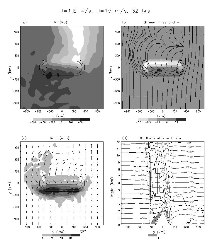
Figure Above: Simulated moist airflow over the ridge-like mountain at Ut/a=17.28. (a) The surface pressure perturbation (in Pa), (b) w (shaded; in ms-1) and streamlines at the first half sigma level, (c) the surface accumulated rainfall (shaded; in mm) and horizontal wind vectors at the first half sigma level, and (d) w(in ms-1) and potential temperature (in K) along the north-south cross section of x=0km. The flow and orographic parameters are U=15ms-1, Nw=0.01127, h=2km, Fw=0.666 and f=10-4s-1. In (d), the cloud boundary is denoted by thick dotted curve for total water content greater than 0.0005 g kg-1, and the cold pool is shaded by θ'<-1K.
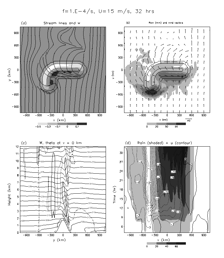
Figure Above: Simulated moist airflow over an arc-shaped mountain for Fw=0.666 (U=15ms-1) at Ut/a=17.28 (32 h). (a) Streamlines and w (shaded; in ms-1) at the first half sigma level, (b) accumulated rainfall (shaded; in mm) and the horizontal wind vectors at the first half sigma level, (c) w (in ms-1) and θ (in K) on the vertical cross section of x=0km, and (d) time evolution of accumulated rainfall (shaded; in mm) and u (in ms-1) at y=-180km.
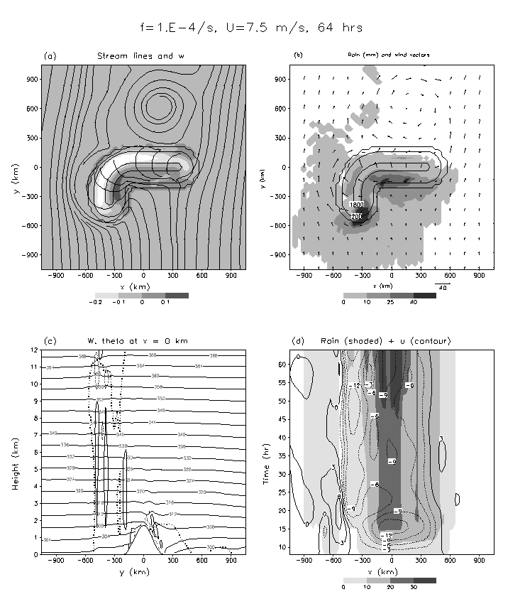
Figure Above: Simulated moist airflow over an arc-shaped mountain for Fw=0.333 (U=7.5ms-1) at Ut/a=17.28 (64 h). (a) Streamlines and w (shaded; in ms-1) at the first half sigma level, (b) accumulated rainfall (shaded; in mm) and the horizontal wind vectors at the first half sigma level, (c) w (in ms-1) and θ (in K) on the vertical cross section of x=0km, and (d) time evolution of accumulated rainfall (shaded; in mm) and u (in ms-1) at y=-180km.
EFFECTS OF MOIST FROUDE NUMBER AND CAPE ON A CONDITIONALLY UNSTABLE FLOW OVER A MESOSCALE MOUNTAIN
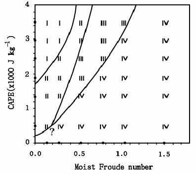
In this study, we perform idealized simulations for a conditionally unstable flow over a two-dimensional mountain ridge in order to investigate the propagation and types of cloud precipitation systems controlled by the unsaturated moist Froude number ( ) and the convective available potential energy (CAPE). A two-dimensional moist flow regime diagram, based on and CAPE, is proposed for a conditionally unstable flow passing over a two-dimensional mesoscale mountain ridge. The characteristics of these flow regimes are: (1) Regime I: flow with an upstream propagating convective system and an early, slowly moving convective system over the mountain; (2) Regime II: flow with a long-lasting orographic convective system over the mountain peak, upslope or lee slope; (3) Regime III: flow with an orographic convective or mixed convective and stratiform precipitation system over the mountain and a downstream propagating convective system; and (4) Regime IV: flow with an orographic stratiform precipitation system over the mountain and possibly a downstream propagating cloud system. Note that the fourth regime (IV) was not included in the flow regimes proposed by Chu and Lin (CL) and Chen and Lin. The propagation of the convective systems are explained by the orographic blocking and density current forcing associated with the cold air outflow produced by evaporative cooling acting against the basic flow, which then determines the propagation and cloud types of the simulated precipitation systems.
Figure Above: The vertical velocity (in ms-1; shaded) and potential temperature (K) at 7 h simulation for (a) CP4F1, (b) CP4F3, (c) CP4F4, and (d) CP4F6 and the corresponding time evolutions of the vertical velocity at 3.6 km height (contour lines: -3, –1, 1, and 3 m s-1) and accumulated rainfall are shown in (e), (f), (g), and (h), respectively (see Table 1 for details). Rainfall greater than 0.1 mm is shaded. Dotted lines indicate elevation (200 m, 1000 m, and 1800 m) where the mountain peak is at x = 0 km. The cloud boundary is denoted by thick dotted curve for total water content greater than 0.0005 g kg-1. (CP0, CP1, CP2, CP3, CP4, CP5) means CAPE = (487, 1372, 1895, 2438, 3000, 3578 J kg-1); (F1, F2, F3, F4, F5, F6) means Fw, moist froude number, ≈ (0.131, 0.262, 0.524, 0.786, 1.048, 1.572).
Figure Above: Flow regimes on the control parameters Fw, moist froude number, and CAPE. The CAPE increases from 487 (CP0), 1372 (CP1), 1895 (CP2), 2438 (CP3), 3000 (CP4), to 3578 (CP5) J kg-1. The last 5 thermodynamic profiles are those used for CP1F2, CP2F2, CP3F2, CP4F2 (CNTL), and CP5F2. The basic wind increases from 2.5 m s-1 to 30 m s-1, which gives Fw = 0.131 to 1.572.Fig Above: Schematic of the flow regimes found in this study. (1) Regime I: flow with upstream propagating convective system and a transient convective system existing in the vicinity of the mountain at earlier time; (2) Regime II: long-lasting orographic convective system over the mountain peak; (3) Regime III: downstream propagating convective system and long-lasting orographic convective or mixed convective and stratiform precipitation system; and (4) Regime IV: a long-lasting orographic stratiform precipitation system over the mountain peak and possibly a downstream propagating cloud system. FD is assumed to be a proxy of CAPE. Symbols C, S, and N denote convective, stratiform, and no cloud types, respectively. Outline (filled) arrow denotes the propagation direction of the precipitation system (cold-air outflow).